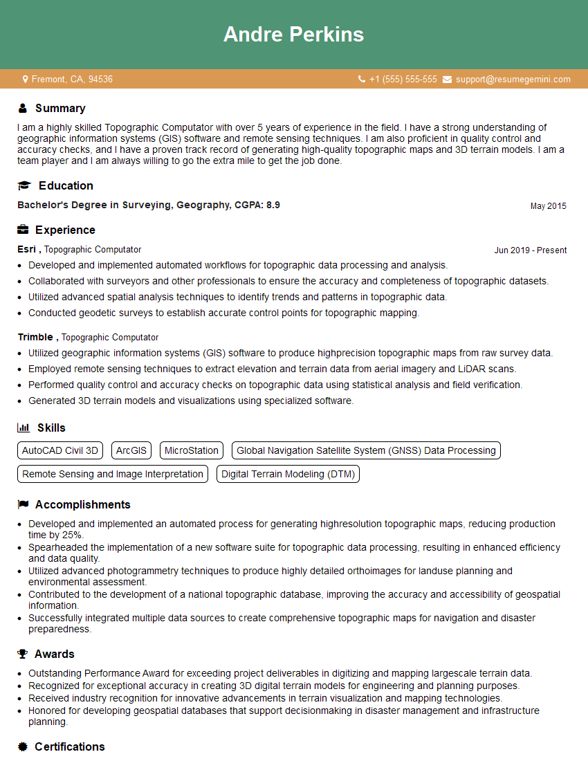
Are you a seasoned Topographic Computator seeking a new career path? Discover our professionally built Topographic Computator Resume Template. This time-saving tool provides a solid foundation for your job search. Simply click “Edit Resume” to customize it with your unique experiences and achievements. Customize fonts and colors to match your personal style and increase your chances of landing your dream job. Explore more Resume Templates for additional options.

Andre Perkins
Topographic Computator
Summary
I am a highly skilled Topographic Computator with over 5 years of experience in the field. I have a strong understanding of geographic information systems (GIS) software and remote sensing techniques. I am also proficient in quality control and accuracy checks, and I have a proven track record of generating high-quality topographic maps and 3D terrain models. I am a team player and I am always willing to go the extra mile to get the job done.
Education
Bachelor’s Degree in Surveying, Geography
May 2015
Skills
- AutoCAD Civil 3D
- ArcGIS
- MicroStation
- Global Navigation Satellite System (GNSS) Data Processing
- Remote Sensing and Image Interpretation
- Digital Terrain Modeling (DTM)
Work Experience
Topographic Computator
- Developed and implemented automated workflows for topographic data processing and analysis.
- Collaborated with surveyors and other professionals to ensure the accuracy and completeness of topographic datasets.
- Utilized advanced spatial analysis techniques to identify trends and patterns in topographic data.
- Conducted geodetic surveys to establish accurate control points for topographic mapping.
Topographic Computator
- Utilized geographic information systems (GIS) software to produce highprecision topographic maps from raw survey data.
- Employed remote sensing techniques to extract elevation and terrain data from aerial imagery and LiDAR scans.
- Performed quality control and accuracy checks on topographic data using statistical analysis and field verification.
- Generated 3D terrain models and visualizations using specialized software.
Accomplishments
- Developed and implemented an automated process for generating highresolution topographic maps, reducing production time by 25%.
- Spearheaded the implementation of a new software suite for topographic data processing, resulting in enhanced efficiency and data quality.
- Utilized advanced photogrammetry techniques to produce highly detailed orthoimages for landuse planning and environmental assessment.
- Contributed to the development of a national topographic database, improving the accuracy and accessibility of geospatial information.
- Successfully integrated multiple data sources to create comprehensive topographic maps for navigation and disaster preparedness.
Awards
- Outstanding Performance Award for exceeding project deliverables in digitizing and mapping largescale terrain data.
- Recognized for exceptional accuracy in creating 3D digital terrain models for engineering and planning purposes.
- Received industry recognition for innovative advancements in terrain visualization and mapping technologies.
- Honored for developing geospatial databases that support decisionmaking in disaster management and infrastructure planning.
Certificates
- Certified Photogrammetrist (CP)
- Certified Geographic Information Systems Professional (GISP)
- Certified Survey Technician (CST)
- Certified Mapping Scientist (CMS)
Career Expert Tips:
- Select the ideal resume template to showcase your professional experience effectively.
- Master the art of resume writing to highlight your unique qualifications and achievements.
- Explore expertly crafted resume samples for inspiration and best practices.
- Build your best resume for free this new year with ResumeGemini. Enjoy exclusive discounts on ATS optimized resume templates.
How To Write Resume For Topographic Computator
- Tailor your resume to each job you apply for. Be sure to highlight the skills and experience that are most relevant to the position.
- Use keywords from the job description in your resume. This will help your resume get noticed by potential employers.
- Proofread your resume carefully before submitting it. Make sure there are no errors in grammar or spelling.
- Get feedback on your resume from a friend, family member, or career counselor. This can help you identify areas that need improvement.
- Use a professional resume template. This will give your resume a polished and professional look.
Essential Experience Highlights for a Strong Topographic Computator Resume
- Utilized GIS software to produce high-precision topographic maps from raw survey data.
- Employed remote sensing techniques to extract elevation and terrain data from aerial imagery and LiDAR scans.
- Performed quality control and accuracy checks on topographic data using statistical analysis and field verification.
- Generated 3D terrain models and visualizations using specialized software.
- Developed and implemented automated workflows for topographic data processing and analysis.
- Collaborated with surveyors and other professionals to ensure the accuracy and completeness of topographic datasets.
- Utilized advanced spatial analysis techniques to identify trends and patterns in topographic data.
- Conducted geodetic surveys to establish accurate control points for topographic mapping.
Frequently Asked Questions (FAQ’s) For Topographic Computator
What is a Topographic Computator?
A Topographic Computator is a professional who uses specialized software and techniques to create topographic maps and 3D terrain models from raw survey data and remote sensing imagery.
What skills are required to be a Topographic Computator?
Topographic Computators need to have a strong understanding of GIS software, remote sensing techniques, and quality control procedures. They also need to be proficient in mathematics and have a good eye for detail.
What is the job outlook for Topographic Computators?
The job outlook for Topographic Computators is expected to be good over the next few years. This is due to the increasing demand for geospatial data in a variety of industries, including engineering, construction, and environmental planning.
What is the average salary for a Topographic Computator?
The average salary for a Topographic Computator is around $60,000 per year.
What are the benefits of being a Topographic Computator?
Topographic Computators can enjoy a variety of benefits, including a good salary, job security, and the opportunity to work on a variety of interesting projects.
What are the challenges of being a Topographic Computator?
Topographic Computators can face a variety of challenges, including working with large datasets, dealing with complex software, and working in remote locations.