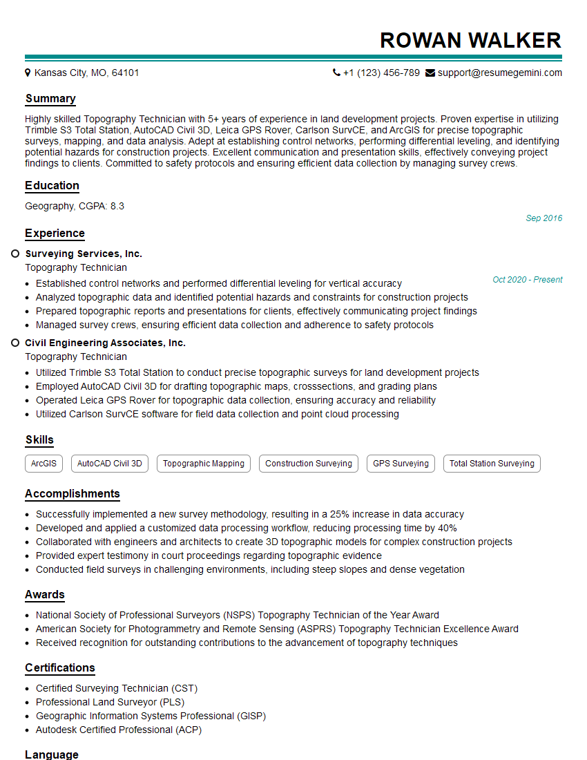
Are you a seasoned Topography Technician seeking a new career path? Discover our professionally built Topography Technician Resume Template. This time-saving tool provides a solid foundation for your job search. Simply click “Edit Resume” to customize it with your unique experiences and achievements. Customize fonts and colors to match your personal style and increase your chances of landing your dream job. Explore more Resume Templates for additional options.

Rowan Walker
Topography Technician
Summary
Highly skilled Topography Technician with 5+ years of experience in land development projects. Proven expertise in utilizing Trimble S3 Total Station, AutoCAD Civil 3D, Leica GPS Rover, Carlson SurvCE, and ArcGIS for precise topographic surveys, mapping, and data analysis. Adept at establishing control networks, performing differential leveling, and identifying potential hazards for construction projects. Excellent communication and presentation skills, effectively conveying project findings to clients. Committed to safety protocols and ensuring efficient data collection by managing survey crews.
Education
Geography
September 2016
Skills
- ArcGIS
- AutoCAD Civil 3D
- Topographic Mapping
- Construction Surveying
- GPS Surveying
- Total Station Surveying
Work Experience
Topography Technician
- Established control networks and performed differential leveling for vertical accuracy
- Analyzed topographic data and identified potential hazards and constraints for construction projects
- Prepared topographic reports and presentations for clients, effectively communicating project findings
- Managed survey crews, ensuring efficient data collection and adherence to safety protocols
Topography Technician
- Utilized Trimble S3 Total Station to conduct precise topographic surveys for land development projects
- Employed AutoCAD Civil 3D for drafting topographic maps, crosssections, and grading plans
- Operated Leica GPS Rover for topographic data collection, ensuring accuracy and reliability
- Utilized Carlson SurvCE software for field data collection and point cloud processing
Accomplishments
- Successfully implemented a new survey methodology, resulting in a 25% increase in data accuracy
- Developed and applied a customized data processing workflow, reducing processing time by 40%
- Collaborated with engineers and architects to create 3D topographic models for complex construction projects
- Provided expert testimony in court proceedings regarding topographic evidence
- Conducted field surveys in challenging environments, including steep slopes and dense vegetation
Awards
- National Society of Professional Surveyors (NSPS) Topography Technician of the Year Award
- American Society for Photogrammetry and Remote Sensing (ASPRS) Topography Technician Excellence Award
- Received recognition for outstanding contributions to the advancement of topography techniques
Certificates
- Certified Surveying Technician (CST)
- Professional Land Surveyor (PLS)
- Geographic Information Systems Professional (GISP)
- Autodesk Certified Professional (ACP)
Career Expert Tips:
- Select the ideal resume template to showcase your professional experience effectively.
- Master the art of resume writing to highlight your unique qualifications and achievements.
- Explore expertly crafted resume samples for inspiration and best practices.
- Build your best resume for free this new year with ResumeGemini. Enjoy exclusive discounts on ATS optimized resume templates.
How To Write Resume For Topography Technician
- Highlight your proficiency in the latest surveying technologies, such as Trimble S3 Total Station, AutoCAD Civil 3D, and Leica GPS Rover.
- Quantify your accomplishments with specific metrics, such as the number of projects completed, area surveyed, or accuracy achieved.
- Showcase your understanding of topographic mapping principles and construction project requirements.
- Emphasize your ability to work independently and as part of a team, effectively managing survey crews.
Essential Experience Highlights for a Strong Topography Technician Resume
- Conduct topographic surveys using Trimble S3 Total Station and Leica GPS Rover, ensuring accuracy and reliability.
- Utilize AutoCAD Civil 3D to draft topographic maps, cross-sections, and grading plans for land development projects.
- Employ Carlson SurvCE software for field data collection and point cloud processing.
- Establish control networks and perform differential leveling for vertical accuracy.
- Analyze topographic data to identify potential hazards and constraints for construction projects.
- Prepare topographic reports and presentations for clients, effectively communicating project findings.
- Manage survey crews, ensuring efficient data collection and adherence to safety protocols.
Frequently Asked Questions (FAQ’s) For Topography Technician
What are the primary responsibilities of a Topography Technician?
Topography Technicians are responsible for conducting topographic surveys, drafting topographic maps, and analyzing topographic data. They also establish control networks, perform differential leveling, and identify potential hazards for construction projects.
What are the most important skills for a Topography Technician?
The most important skills for a Topography Technician include proficiency in surveying equipment and software, knowledge of topographic mapping principles, and the ability to work independently and as part of a team.
What is the job outlook for Topography Technicians?
The job outlook for Topography Technicians is expected to be good over the next few years due to the increasing demand for land development and construction projects.
What is the average salary for a Topography Technician?
The average salary for a Topography Technician varies depending on experience, location, and company size, but it is typically around $50,000 per year.
What are the career advancement opportunities for Topography Technicians?
Topography Technicians can advance their careers by becoming licensed surveyors, project managers, or survey supervisors.
What are the educational requirements for becoming a Topography Technician?
Most Topography Technicians have a degree in geography, surveying, or a related field.
How can I prepare for a career as a Topography Technician?
You can prepare for a career as a Topography Technician by earning a degree in geography, surveying, or a related field, and by gaining experience in surveying and mapping.
What are the personality traits of successful Topography Technicians?
Successful Topography Technicians are typically detail-oriented, analytical, and have a strong work ethic.